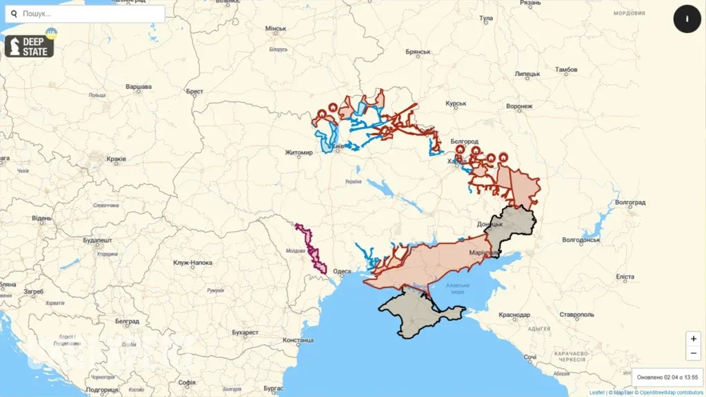
Deep State – an overview of the map of hostilities in Ukraine

Deep State is an interactive map that allows you to monitor the progress of the Russian-Ukrainian war in real time and receive unbiased information about the situation at the front. The map was launched shortly after Russia’s full-scale armed invasion of Ukraine. Today, it can be viewed both online on the developer’s official website and in the Android and iOS apps.

Read also our article: CrowdStrike reveals causes of global outage on Windows computers
Map of hostilities in the Deep State online for today
Prerequisites for creating an interactive map of the Deep State
February 24, 2022 divided the lives of Ukrainians into “before” and “after”. On this day, at 3:40 am, Putin launched a cynical armed attack on peaceful Ukrainian cities, whose residents were sleeping peacefully in their beds. Russian troops attacked Ukraine from Russia, Belarus and occupied Crimea, bombing military depots and airfields to prevent Ukrainians from defending themselves. Explosions were heard in Kyiv, Kharkiv, Dnipro and many other cities of Ukraine.
At the same time, the enemy began to seize settlements in the south, east, and north of Ukraine that bordered on regions where Russian troops were stationed. Millions of Ukrainians were forced to leave their homes and move to safer places to save their families from Putin’s ruthless and inept army.
In the context of a full-scale armed invasion of Ukraine, there was a need for an interactive map that could objectively reflect the situation at the front and in the occupied territories in real time. The map was created by the DeepStateUA development team, which, before the war, covered news related to COVID-19 and international geopolitics on the eponymous telegram channel.
After Russia’s armed attack on Ukraine, the Deep State USA community decided to focus exclusively on the events of the Russian-Ukrainian war. In March 2022, the DeepStateMAP website, based on OpenStreetMaps, was launched. In March 2023, the Deep State app for Android was launched, and at the end of April of the same year, the same app appeared for iOS.

What is an online map of Deep State?
Deep State is an interactive map that allows you to follow the course of hostilities in Ukraine online. It allows you to see on a daily basis which territories are being liberated or lost by the Ukrainian Armed Forces, where the main enemy forces are concentrated, and how events are developing at the front.
The map has a user-friendly interface and clear labels, which makes it possible for people with any level of education and technical training to view it.
Deep State users have 2 languages to choose from: English and Ukrainian. In addition, the map can be viewed in three different formats: standard, satellite, and topographic.
The Deep State map has many features that distinguish it from other interactive projects. Here are some of them:
- DeepStateMAP shows the occupied and de-occupied regions of Ukraine, as well as the territories of other countries occupied by the Russian army.
- The map shows the front line and the changes that occur on it every day. This allows users to monitor the progress of hostilities along the entire contact line and analyze the dynamics of the war.
- Deep State shows the locations of Russian military airfields, headquarters and units, directions of enemy attacks, and much other important information that helps the Ukrainian Armed Forces destroy the enemy.
- The map has a function that allows you to measure the range of enemy positions hit by CAESAR, M777, HIMARS and other artillery systems. It can also be used to simulate the force of a nuclear explosion, monitor the radiation background and weather in all regions of Ukraine.
In addition to the publicly available functionality that can be used by everyone, Deep State has a closed version. It contains information about the location of enemy trenches and other classified data and is intended only for the Armed Forces of Ukraine.
How to read Deep State correctly?
To understand the map, you need to study its symbols. The most important ones look like this:
- red – regions occupied by Putin’s army after February 24, 2022;
- dark red – Russian-occupied territories of ORDLO and Crimea;
- green – regions de-occupied by the Ukrainian army;
- blue – territories de-occupied by the Armed Forces of Ukraine in the last 2 weeks;
- gray – territories whose status needs to be clarified;
- light pink – territories of other states seized by the Kremlin (Transnistria, Abkhazia, South Ossetia, Chechnya);
- a crossed-out rhombus (according to NATO standards) or a picture of a pig – a unit of the Russian army;
- a rhombus with a small letter “x” (according to NATO standards) or an image of a tent – enemy headquarters;
- a rhombus with a wheel and an airplane or an image of an airplane on a runway – an enemy airfield;
- a diamond with the inscription “SEC” or a picture of a steam locomotive – enemy railroad;
- red arrow – directions of enemy attacks.
Deep State developers emphasize that only the leadership of the General Staff of the Armed Forces of Ukraine has accurate maps of the war. The map presented on the DeepStateMAP website and in the apps of the same name tries to be as close as possible to the situation at the front, but there may be inaccuracies. To correct them, users are invited to contact the portal team.
Since the Deep State map is not 100% accurate, the developers warn Ukrainians not to use it to plan routes in regions where military operations are ongoing. To do so, it is better to follow the green corridors and other routes recommended by the official authorities.
Video about interactive map of the Deep State
If you are interested in learning more about the Deep State map and its developers, we suggest watching a YouTube video dedicated to this famous interactive project.
Frequently asked questions and answers
To do this, you need to install the DeepStateMAP application on your mobile device. Owners of Android smartphones can do this via Google Play. iPhone users need to download the application from the App Store.
Unfortunately, it does not. The developers did not install this option on the map.
DeepStateMAP has no paid subscriptions or options. Everyone can use the map for free.
For some time, the map was available to residents of the Russian Federation, but anyone accessing it from Russian IP addresses was presented with information before viewing it, offering Putin’s troops to surrender to the Ukrainian armed forces. In May 2023, Deep State in Russia was blocked by the Kremlin. Currently, you can only view the map in Russia if you are connected to a VPN.
To do this, click on the icon with the image of interest. After that, a text with the necessary information will appear on Deep State, for example, the 71st Guards Motorized Rifle Regiment, Borisoglebsk airfield, 8th Combined Arms Army, etc.
The author of the Portal UKRexperts
Співпраця - текст
We are sure that knowledge should be accessible to everyone, and that is why UkrExperts strives to be your first choice when it comes to enriching intellectual potential.


